HIGH POINT IRELAND - INFORMATION HUB
  • About
    • Contact us
    • Follow us >
      • Twitter
      • Facebook
    • FAQs
    • Accolades
    • Mission statement
    • Terms & conditions >
      • Terms & conditions for advertisers
      • Privacy policy
    • Website performance
    • Highpointeering
    • Highpointography
    • Our point-scoring system
  • High Points
    • Locations >
      • Carrauntoohil 1,039m
      • Brandon Mountain 952m
      • Lugnaquillia Mountain 925m
      • Galtymore Mountain 918m
      • Baurtregaum 851m
      • Slieve Donard 850m
      • Mullaghcleevaun 849m
      • Mangerton Mountain 838m
      • Purple Mountain 832m
      • Mweelrea 814m
      • Nephin 806m
      • Mount Leinster 794m
      • Knockmealdown 793m
      • Kilclooney Mountain 792m
      • Stumpa Duloigh 784m
      • Mullaghanattin 773m
      • Barrclashcame 772m
      • Coomacarrea 772m
      • Croagh Patrick 764m
      • Kippure 757m
      • Errigal Mountain 751m
      • Blackstairs Mountain 735m
      • Benbaun 729m
      • Slieve Carr 721m
      • Slievenamon 721m
      • Corranabinnia 716m
      • Knockboy 706m
      • Binn idir an da Log 702m
      • Ben Gorm 700m
      • Birreencorragh 698m
      • Keeper Hill 694m
      • The Paps East 694m
      • Knocknadobar 690m
      • Croaghaun 688m
      • Hungry Hill 685m
      • Maumtrasna 682m
      • Sawel Mountain 678m
      • Croaghgorm 674m
      • Slievemore (Achill Island) 671m
      • Slieve Muck 670m
      • Cuilcagh 665m
      • Knockowen 658m
      • Mullaghanish 649m
      • Truskmore 647m
      • Musheramore 644m
      • Truskmore Southeast Slope 631m
      • Mullaghaneany 627m
      • Slieve Snaght 615m
      • Croghan Mountain 606m
      • Garraun 598m
      • Slieve League 595m
      • Slieve Foye 589m
      • Glendoo Mountain 586m
      • Slieve Anierin 585m
      • Slieve Gullion 573m
      • Oughtmore 569m
      • Trostan 550m
      • Shehy More 546m
      • Knockalongy 544m
      • Slievenanee 543m
      • Corraun Hill East Top 541m
      • Moylenanav 539m
      • Nowen Hill 535m
      • Slieve Croob 534m
      • Moylussa 532m
      • Seefin Mountain 528m
      • Arderin 527m
      • Arroo 523m
      • Mount Eagle 516m
      • Brandon Hill 515m
      • Coomagearlahy 506m
      • Raghtin More 502m
      • Foilclogh 497m
      • Bulbin 494m
      • Knockoura 490m
      • Devilsbit Mountain 480m
      • Divis 478m
      • Agnews Hill 474m
      • Loughsalt Mountain 469m
      • Minaun 466m
      • Slievereagh 465m
      • Crockauns 463m
      • Knockmore 462m
      • Cullaun 460m
      • Carrane Hill 458m
      • Tountinna 457m
      • Divis West Slope 455m
      • Baraveha 451m
      • Barnesmore 451m
      • Boleybrack 449m
      • Croaghmoyle 430m
      • Tievealehid 429m
      • Knocknaskagh 427m
      • Seltannasaggart Southeast Slope 412m
      • Bolus 410m
      • Mount Gabriel 407m
      • Maghera 400m
      • Belmore Mountain 398m
      • Slievecallan 391m
      • Croaghleheen 385m
      • Slieve Beagh 380m
      • Maumakeogh 379m
      • Cupidstown Hill 379m
      • Cappaghabaun Mountain East 378m
      • Slieve Beagh East Top 373m
      • Slievenamuck 369m
      • Culliagh Southeast Top 369m
      • Carrigatuke 365m
      • Knockalla Mountain 363m
      • Castlequin Hill 361m
      • Kesh Corann 359m
      • Shannavara 358m
      • Cnoc Mordain 354m
      • Clomantagh Hill 349m
      • Knocknasilloge 346m
      • Seefin 345m
      • Slieve Elva 344m
      • Tawnaghmore 340m
      • Knocknamuck 340m
      • Loughanleagh 339m
      • Gregory Hill 336m
      • Clogrennan Hill 336m
      • Crocknasmug 328m
      • Collin 328m
      • Slieve Glah 320m
      • Brougher Mountain 317m
      • Drumkeeragh Hill 315m
      • Carricktriss Gorse 314m
      • Knocknamaddree 313m
      • Carn Hill 312m
      • Woodcock Hill 310m
      • Keeraunnageeragh 305m
      • Carronadavderg 301m
      • Errisbeg 300m
      • Croaghmore 292m
      • Knockfeerina 288m
      • Crockalough 282m
      • Barranisky 280m
      • Corn Hill 278m
      • Slieve na Calliagh 276m
      • Knockanallig 267m
      • Geokaun 266m
      • Slieve Bawn 262m
      • Holywell Hill 260m
      • Mullaghmeen 258m
      • Benwee Head 255m
      • Brislagh 255m
      • Cnoc Bolais 252m
      • Scariff Island 252m
      • Croaghnamaddy 252m
      • Mount Oriel 251m
      • Croaghegly 245m
      • Knocknascollop Northwest Top 244m
      • Forth Mountain 237m
      • Croghan Hill 234m
      • Dunmurry Hill 233m
      • Cluidaniller West Top 227m
      • Murren Hill 227m
      • Inch Top 222m
      • Needles Eye 217m
      • Cairngaver 217m
      • Tearaght Island 200m
      • Knockastia 200m
      • Inishturk 191m
      • Knockbrack 176m
      • Inishnabro 175m
      • Inishtooskert 172m
      • Knockroe 168m
      • Knocknaheeny 161m
      • Cnoicin an tSeabhaic 160m
      • Puffin Island 159m
      • Slieveard 134m
      • Inishmore (Galway) 123m
      • Lettermore Island 117m
      • Slievemore (Sherkin Island) 101m
      • Great Island 95m
      • Inishbofin 89m
      • Tory Island 83m
      • Inishmaan 79m
      • Meakstown 76m
      • Barnacranny Hill 75m
      • Boa Island 72m
      • Inishmore (Fermanagh) 72m
      • An Tur Faire 60m
      • Gorumna Island 53m
      • Whiddy Island 50m
    • Sub-lists >
      • Province High Points
      • County High Points
      • Local Council High Points
      • Range High Points
      • Major Island High Points
      • Major River High Points
      • 20km Isolation High Points
      • 500m Prominence High Points
      • Accessible High Points (Level 1)
      • Accessible High Points (Level 2)
      • Isol-Prom High Points
      • Essential High Points
      • Connacht High Points
      • Leinster High Points
      • Munster High Points
      • Ulster High Points
  • Community
    • Participating charities
    • Our partners
    • Individuals
    • Walking guide services
    • Walking clubs
    • Walking events
    • Visitor facilities >
      • Accommodation
      • Food & Drink
      • Shopping
      • Activities
      • Transport
    • Recommended websites
    • Social media
    • Our Regional Network
  • Get Involved
    • Become a Highpointeer
    • Share the adventure >
      • Become a contributor
      • Submit a blog article
      • High Point location hashtags
    • Support local businesses
    • Advertise your walking guide service
    • Advertise your walking club
    • Advertise your walking event
    • Advertise your business
  • Initiatives
    • Awards >
      • Highpointeer of the Year
      • Young Highpointeer of the Year
      • Highpointeering Guide of the Year
      • Highpointeering Club of the Year
      • Highpointeering Event of the Year
      • High Point of the Year
      • High Point Photo of the Year
      • Certificates of Completion
      • Certificates of Excellence
    • Leagues >
      • Provinces League >
        • Team Connacht
        • Team Leinster
        • Team Munster
        • Team Ulster
      • Counties League >
        • Team County Antrim
        • Team County Armagh
        • Team County Carlow
        • Team County Cavan
        • Team County Clare
        • Team County Cork
        • Team County Derry
        • Team County Donegal
        • Team County Down
        • Team County Dublin
        • Team County Fermanagh
        • Team County Galway
        • Team County Kerry
        • Team County Kildare
        • Team County Kilkenny
        • Team County Laois
        • Team County Leitrim
        • Team County Limerick
        • Team County Longford
        • Team County Louth
        • Team County Mayo
        • Team County Meath
        • Team County Monaghan
        • Team County Offaly
        • Team County Roscommon
        • Team County Sligo
        • Team County Tipperary
        • Team County Tyrone
        • Team County Waterford
        • Team County Westmeath
        • Team County Wexford
        • Team County Wicklow
    • Challenges >
      • Set List Challenges
      • 10,000m Challenge
      • 25 High Points Challenge
    • Ireland High Points Week
    • Youth Involvement Programme
    • Photo competition
  • Extra
    • Your stories
    • Our news
    • Highpointeer Score Form
    • Being a Highpointeer
    • Logging instructions
    • Our other websites

Cairngaver: second time lucky

29/5/2017

0 Comments


Cairngaver is a little known and relatively low, transmitter-topped hill in north County Down. Its 217m summit is the highest point in the Craigantlet Hills - a small range just northeast of Belfast City. Read Martin McAlinden's story of his second attempt to reach its summit.

I’m slightly embarrassed now that I was unable to reach the 217m summit of Cairngaver on my first attempt back in 2009. In my defence, this was before the age of widespread smartphones equipped with hiking apps, GPS and 4G. I’d arrived somewhat ill-prepared following an appointment nearby, without a map and with only the knowledge that the summit lay beyond the top of Cairn Wood, a pretty forest popular with walkers. I’d followed the maze of trails ever upwards without any luck, ultimately reaching a quarry and not finding an obvious route beyond it.
 
I decided to give Cairngaver another go recently, after visiting a friend living in Belfast. This time I was armed with the ViewRanger app which helpfully shows the main trails through the forest. Once again I started from the forest parking area on the B170, an inland route between Belfast and Bangor.
 
Picture
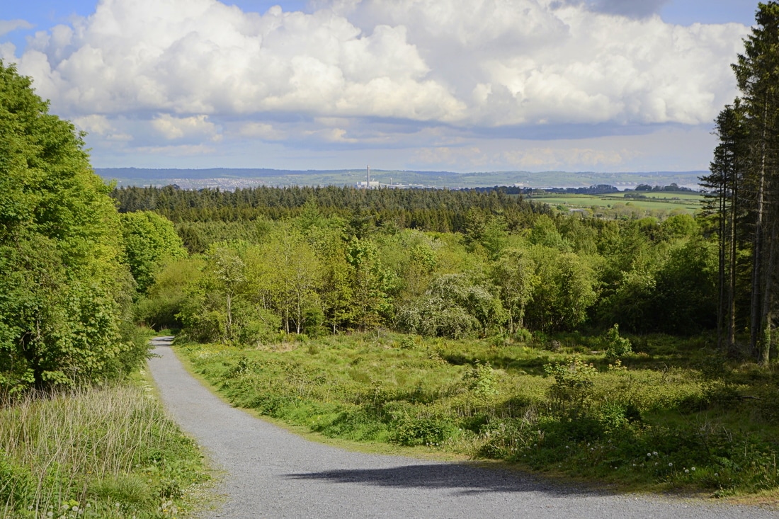
Starting off from Cairn Wood
 
I followed the main perimeter trail up to the top of the forest and then, knowing I should be aiming southeast, picked up a minor trail which gave a glimpse of the transmitters and led towards them. The summit area was reached after passing through gaps in a couple of hedges. Having skirted the quarry edge again, I realised that my mistake last time was thinking the summit was to the right of it rather than the left.
 
Despite the various masts and service buildings, Cairngaver’s summit is quite a peaceful place, with a trig pillar topping an old cairn that’s shaded by trees. The views are surprisingly extensive, though you’ll have to walk around a bit to appreciate them. One thing that struck me was that this area of commuter towns is still very green and pretty when seen from above.
 
Sights included part of Belfast and its surrounding hills, the familiar, jagged line of the Mourne Mountains to the south, the mouth of Belfast Lough and the Antrim Coast to the northeast, and across the sea to Scotland and even the Isle of Man; the first time I’ve been sure I’ve seen it from Ireland. Closer to hand was the fairytale Scrabo Tower rising above Newtownards, with the Ards Peninsula beyond.
 
Picture
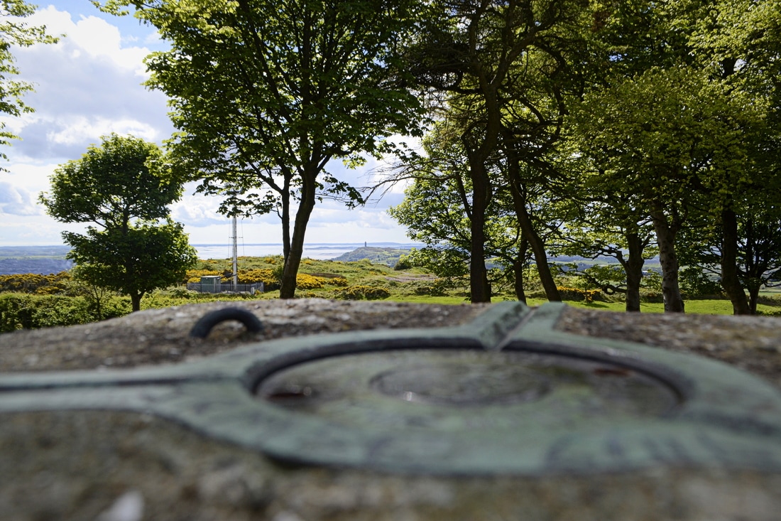
The view to Scrabo Tower and Strangford Lough from the trig pillar

Having taken time to enjoy the various views, I headed back down the same way. This was a very enjoyable trip, not just because of the satisfaction in finally ‘conquering’ this obscure hill but because Cairngaver punches well above its modest height.

Read more...

This is a short version of an article from Martin McAlinden's own Hike Cycle Ireland blog. For the full story and a larger selection of photographs from Martin's Cairngaver walk, please visit his original article.

0 Comments

Your comment will be posted after it is approved.


Leave a Reply.

    Thank you for visiting the High Point Ireland blog: the  dedicated news feed of the High Point Ireland website. Feel free to get in touch if you would like to become a guest blogger.

    Archives

    June 2017
    May 2017
    February 2017
    January 2017

    Categories

    All
    2016
    Certificate Of Completion
    Certificate Of Excellence
    Competition
    County Gribbons
    Highpointeer Of The Year
    #HighPointIrelandPhoto
    Local Council Gribbons
    Range Gribbons
    Review
    Upcoming Event
    Walk Report

    RSS Feed

Your recent stories


Our recent news


Follow us


Home
About
High Points
Community
Get involved
Initiatives
News Hub
Extra

Supporting good causes

Our supporters


Our partners

Walking links


Disclaimer


If you are planning to visit any of the locations on the Gribbon list of Ireland's major geographical High Points, please be aware that Highpointeering, rambling, hill-walking, hiking, mountaineering, mountain running and cycling are risk sports. High Point Ireland, Kieron Gribbon (the website's author and founder of High Point Ireland) and Donard Media (the website's publisher) accept no responsibility for any injury, loss or inconvenience sustained by anyone using this website. Personal safety is entirely the participant's own responsibility.
The inclusion of locations on the Gribbon list of Ireland's major geographical High Points is based entirely on each location's ability to meet the necessary criteria for at least one of the eight primary sub-lists contained on this website. It should not be assumed that access is permitted to any of the High Point locations on the list. High Point Ireland, Kieron Gribbon and Donard Media recommend that anyone planning to visit any of the High Point locations on the list should check for potential access restrictions and to request permission from the relevant landowner(s) in advance.

Copyright © Kieron Gribbon 2015 - 2018

The High Point Ireland website has been created by Kieron Gribbon (author of Ireland's County High Points: A Walking Guide
and The Gribbons: A Complete List of Ireland's Major Geographical High Points). Kieron is also the creator of
The Ireland Walking Guide, The Ireland Sightseeing Guide and The Ireland Geography Guide websites.

The Ireland Walking Guide - www.theirelandwalkingguide.com
The Ireland Sightseeing Guide - www.theirelandsightseeingguide.com
High Point Ireland - www.highpointireland.com
The Ireland Geography Guide - www.theirelandgeographyguide.com
Ireland's County High Points: A Walking Guide

  • About
    • Contact us
    • Follow us >
      • Twitter
      • Facebook
    • FAQs
    • Accolades
    • Mission statement
    • Terms & conditions >
      • Terms & conditions for advertisers
      • Privacy policy
    • Website performance
    • Highpointeering
    • Highpointography
    • Our point-scoring system
  • High Points
    • Locations >
      • Carrauntoohil 1,039m
      • Brandon Mountain 952m
      • Lugnaquillia Mountain 925m
      • Galtymore Mountain 918m
      • Baurtregaum 851m
      • Slieve Donard 850m
      • Mullaghcleevaun 849m
      • Mangerton Mountain 838m
      • Purple Mountain 832m
      • Mweelrea 814m
      • Nephin 806m
      • Mount Leinster 794m
      • Knockmealdown 793m
      • Kilclooney Mountain 792m
      • Stumpa Duloigh 784m
      • Mullaghanattin 773m
      • Barrclashcame 772m
      • Coomacarrea 772m
      • Croagh Patrick 764m
      • Kippure 757m
      • Errigal Mountain 751m
      • Blackstairs Mountain 735m
      • Benbaun 729m
      • Slieve Carr 721m
      • Slievenamon 721m
      • Corranabinnia 716m
      • Knockboy 706m
      • Binn idir an da Log 702m
      • Ben Gorm 700m
      • Birreencorragh 698m
      • Keeper Hill 694m
      • The Paps East 694m
      • Knocknadobar 690m
      • Croaghaun 688m
      • Hungry Hill 685m
      • Maumtrasna 682m
      • Sawel Mountain 678m
      • Croaghgorm 674m
      • Slievemore (Achill Island) 671m
      • Slieve Muck 670m
      • Cuilcagh 665m
      • Knockowen 658m
      • Mullaghanish 649m
      • Truskmore 647m
      • Musheramore 644m
      • Truskmore Southeast Slope 631m
      • Mullaghaneany 627m
      • Slieve Snaght 615m
      • Croghan Mountain 606m
      • Garraun 598m
      • Slieve League 595m
      • Slieve Foye 589m
      • Glendoo Mountain 586m
      • Slieve Anierin 585m
      • Slieve Gullion 573m
      • Oughtmore 569m
      • Trostan 550m
      • Shehy More 546m
      • Knockalongy 544m
      • Slievenanee 543m
      • Corraun Hill East Top 541m
      • Moylenanav 539m
      • Nowen Hill 535m
      • Slieve Croob 534m
      • Moylussa 532m
      • Seefin Mountain 528m
      • Arderin 527m
      • Arroo 523m
      • Mount Eagle 516m
      • Brandon Hill 515m
      • Coomagearlahy 506m
      • Raghtin More 502m
      • Foilclogh 497m
      • Bulbin 494m
      • Knockoura 490m
      • Devilsbit Mountain 480m
      • Divis 478m
      • Agnews Hill 474m
      • Loughsalt Mountain 469m
      • Minaun 466m
      • Slievereagh 465m
      • Crockauns 463m
      • Knockmore 462m
      • Cullaun 460m
      • Carrane Hill 458m
      • Tountinna 457m
      • Divis West Slope 455m
      • Baraveha 451m
      • Barnesmore 451m
      • Boleybrack 449m
      • Croaghmoyle 430m
      • Tievealehid 429m
      • Knocknaskagh 427m
      • Seltannasaggart Southeast Slope 412m
      • Bolus 410m
      • Mount Gabriel 407m
      • Maghera 400m
      • Belmore Mountain 398m
      • Slievecallan 391m
      • Croaghleheen 385m
      • Slieve Beagh 380m
      • Maumakeogh 379m
      • Cupidstown Hill 379m
      • Cappaghabaun Mountain East 378m
      • Slieve Beagh East Top 373m
      • Slievenamuck 369m
      • Culliagh Southeast Top 369m
      • Carrigatuke 365m
      • Knockalla Mountain 363m
      • Castlequin Hill 361m
      • Kesh Corann 359m
      • Shannavara 358m
      • Cnoc Mordain 354m
      • Clomantagh Hill 349m
      • Knocknasilloge 346m
      • Seefin 345m
      • Slieve Elva 344m
      • Tawnaghmore 340m
      • Knocknamuck 340m
      • Loughanleagh 339m
      • Gregory Hill 336m
      • Clogrennan Hill 336m
      • Crocknasmug 328m
      • Collin 328m
      • Slieve Glah 320m
      • Brougher Mountain 317m
      • Drumkeeragh Hill 315m
      • Carricktriss Gorse 314m
      • Knocknamaddree 313m
      • Carn Hill 312m
      • Woodcock Hill 310m
      • Keeraunnageeragh 305m
      • Carronadavderg 301m
      • Errisbeg 300m
      • Croaghmore 292m
      • Knockfeerina 288m
      • Crockalough 282m
      • Barranisky 280m
      • Corn Hill 278m
      • Slieve na Calliagh 276m
      • Knockanallig 267m
      • Geokaun 266m
      • Slieve Bawn 262m
      • Holywell Hill 260m
      • Mullaghmeen 258m
      • Benwee Head 255m
      • Brislagh 255m
      • Cnoc Bolais 252m
      • Scariff Island 252m
      • Croaghnamaddy 252m
      • Mount Oriel 251m
      • Croaghegly 245m
      • Knocknascollop Northwest Top 244m
      • Forth Mountain 237m
      • Croghan Hill 234m
      • Dunmurry Hill 233m
      • Cluidaniller West Top 227m
      • Murren Hill 227m
      • Inch Top 222m
      • Needles Eye 217m
      • Cairngaver 217m
      • Tearaght Island 200m
      • Knockastia 200m
      • Inishturk 191m
      • Knockbrack 176m
      • Inishnabro 175m
      • Inishtooskert 172m
      • Knockroe 168m
      • Knocknaheeny 161m
      • Cnoicin an tSeabhaic 160m
      • Puffin Island 159m
      • Slieveard 134m
      • Inishmore (Galway) 123m
      • Lettermore Island 117m
      • Slievemore (Sherkin Island) 101m
      • Great Island 95m
      • Inishbofin 89m
      • Tory Island 83m
      • Inishmaan 79m
      • Meakstown 76m
      • Barnacranny Hill 75m
      • Boa Island 72m
      • Inishmore (Fermanagh) 72m
      • An Tur Faire 60m
      • Gorumna Island 53m
      • Whiddy Island 50m
    • Sub-lists >
      • Province High Points
      • County High Points
      • Local Council High Points
      • Range High Points
      • Major Island High Points
      • Major River High Points
      • 20km Isolation High Points
      • 500m Prominence High Points
      • Accessible High Points (Level 1)
      • Accessible High Points (Level 2)
      • Isol-Prom High Points
      • Essential High Points
      • Connacht High Points
      • Leinster High Points
      • Munster High Points
      • Ulster High Points
  • Community
    • Participating charities
    • Our partners
    • Individuals
    • Walking guide services
    • Walking clubs
    • Walking events
    • Visitor facilities >
      • Accommodation
      • Food & Drink
      • Shopping
      • Activities
      • Transport
    • Recommended websites
    • Social media
    • Our Regional Network
  • Get Involved
    • Become a Highpointeer
    • Share the adventure >
      • Become a contributor
      • Submit a blog article
      • High Point location hashtags
    • Support local businesses
    • Advertise your walking guide service
    • Advertise your walking club
    • Advertise your walking event
    • Advertise your business
  • Initiatives
    • Awards >
      • Highpointeer of the Year
      • Young Highpointeer of the Year
      • Highpointeering Guide of the Year
      • Highpointeering Club of the Year
      • Highpointeering Event of the Year
      • High Point of the Year
      • High Point Photo of the Year
      • Certificates of Completion
      • Certificates of Excellence
    • Leagues >
      • Provinces League >
        • Team Connacht
        • Team Leinster
        • Team Munster
        • Team Ulster
      • Counties League >
        • Team County Antrim
        • Team County Armagh
        • Team County Carlow
        • Team County Cavan
        • Team County Clare
        • Team County Cork
        • Team County Derry
        • Team County Donegal
        • Team County Down
        • Team County Dublin
        • Team County Fermanagh
        • Team County Galway
        • Team County Kerry
        • Team County Kildare
        • Team County Kilkenny
        • Team County Laois
        • Team County Leitrim
        • Team County Limerick
        • Team County Longford
        • Team County Louth
        • Team County Mayo
        • Team County Meath
        • Team County Monaghan
        • Team County Offaly
        • Team County Roscommon
        • Team County Sligo
        • Team County Tipperary
        • Team County Tyrone
        • Team County Waterford
        • Team County Westmeath
        • Team County Wexford
        • Team County Wicklow
    • Challenges >
      • Set List Challenges
      • 10,000m Challenge
      • 25 High Points Challenge
    • Ireland High Points Week
    • Youth Involvement Programme
    • Photo competition
  • Extra
    • Your stories
    • Our news
    • Highpointeer Score Form
    • Being a Highpointeer
    • Logging instructions
    • Our other websites